


Access to Sydney’s city centre has always been one of the major challenges of previous high speed rail concepts. The density of existing development, the lack of suitable transport corridors and the formidable terrain mean that there is no easy way to access Central Station on a high-speed alignment. There have been three main approaches taken in the past:
- The “money no object” approach just puts everything underground as soon as things get difficult. This was (of course) the approach taken in the 2013 government study, which proposed what the transport minister Anthony Albanese famously described as “a cracker of a tunnel” – by far the longest in the world at 67km (and a whopping cost of $11.4 billion on its own).
- The “bypass” approach, where city centre access is abandoned in favour of a western Sydney terminus, usually at Parramatta, and then continuing north using the Central Coast line via Hornsby. This seems to be the assumed outcome in recent infrastructure literature which often shows configurations such as this. It’s a sub-optimal approach though, because it’s still another hour to the CBD on the Parramatta line. Kind-of puts a dent in the claim of “sub-three hour travel” between Sydney and Melbourne.
- The “stuff it” approach, where they just stop the line at the city fringe. Some approaches terminate the HSR line at a fringe station like Campbelltown (a lá Speedrail) while others used the existing rail lines with no modification at reduced speeds (like the VFT).
None of these approaches are suitable for Hot Rails; we’re not trying to replace air travel, we’re trying to expand the 1-hour commute envelope. And that means 1 hour to the CBD, not to Parramatta. We need to make as much use as possible of existing corridors. The rail corridors are pretty limiting; in the outer suburbs it’s ok, but the further in you get, the windier the corridors get (typical radius is about 350-400m). But even worse is the fact that these corridors don’t have much spare capacity. There’s paltry little room for extra trains, and no room to build extra tracks.
In a nutshell, it’s not going to be easy to get to Central at high speeds. However it’s not impossible; we don’t have to throw our hands up in the air and say it can’t be done, or can’t be done except by tunnel. This post will seek to identify possibilities not considered in previous studies.
Current situation
Today, the scheduled travel time from Sydney Central to Campbelltown is about one hour and four minutes on the East Hills line. The express Explorer/XPT service is only very slightly better at 59 minutes. This is over a distance of 45.8km, meaning the average speed is under 50km/h (46.6km/h for the XPT, to be precise); that leaves a lot of room for improvement. Even if we could just average 100km/h, you’d cut the travel time in half to under 30 minutes. The minimum radius on the East Hills Line is about 400m through the Wolli Creek corridor; this would allow tilting trains to travel at upwards of 116km/h. Couldn’t we just take the easy option and use the existing line at lower speeds? Even if we achieved 200km/h, we’re still only going to save another 15 minutes or so.
The problem with this idea, adopted by most of the big private-sector proposals of the 1980s and 1990s, is that the Sydney rail network is a lot more congested than it was when those proposals were made. The East Hills Line is already quadruplicated from Revesby Station onward, and there is no room for extra tracks without substantial civil infrastructure works and possibly land acquisitions. The tracks that exist are congested and becoming more so; the NSW government’s 2012 Transport Masterplan predicted that the East Hills corridor would be the most congested in the city by 2030:
Sydney rail corridor congestion (2031 projection). Source: NSW Transport Masterplan 2012
This pretty-much eliminates the East Hills corridor as an option. Unless major works were undertaken to widen the corridor, it would be unable to cope with an additional service of any speed. Even if it could somehow be widened, it would still only be a 100km/h alignment, making the vast expense a low-benefit proposition. The other inner-west corridors (Bankstown Line and Western Line) are also at or near capacity, and have equally tight or inferior curve geometry. Therefore it appears clear that in order to access Central Station at all, we will need to tunnel under the inner west. The question then becomes: how do we minimise the length of the tunnel?
Well, we stay above ground for as long as possible. Even elevated viaducts are a lot cheaper than tunnels. We’ve got to make the greatest possible use of existing corridors to get as close as we can to Central before going underground. So where are those corridors?
East Hills line west of Revesby
Although crowded and with little room for expansion in the inner suburbs, the East Hills line is actually fairly conducive to expansion west of Revesby Station (19km as the crow flies from Central). The corridor is wide (40m) only dual-track and has room on both sides for extra tracks. After Revesby, the track is quadruplicated, the corridor is narrower (40m total width but with only 25m useful trackbed due to being elevated on a retained embankment), and it is therefore far harder to add extra capacity. Still, the alignment is suitable for high-speed operation with only minor deviations until Narwee Station (15 km from Central), so it may be possible to use the corridor until there by building an elevated alignment at lower cost than a tunnel.
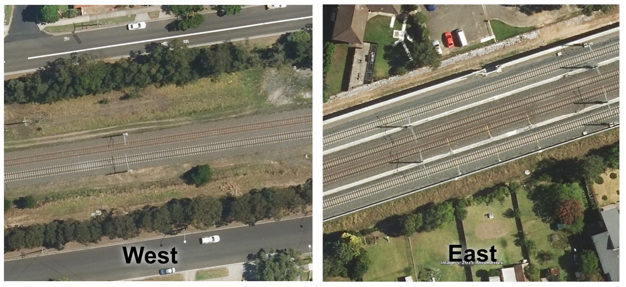
East Hills corridor to the west and east of Revesby Station. Base images: Aerometrex via Google Earth
Inner West Line and Chullora yards
Instead of changing to the East Hills Line at Glenfield, we could follow the Cumberland Line north to Cabramatta, then head east on the Inner West line. This option was rejected by the 2013 government study on the grounds of the subsequent Western Line being at capacity, uncertainty over the future capacity of the Inner West line, and the unfavourable geometry of that alignment. However we can see that the NSW government projects low congestion on the Inner West line out to 2031, and that with very few modifications this corridor could allow high-speeds (the minimum radius is about 600m at Cabramatta Junction). It’s illogical to reject this option on the grounds that the Western Line is at capacity, when the plan is to be in tunnel by that time anyway. It additionally seems excessively cautious to reject any possibility of using the Inner West Line due to mere “uncertainty” over its future capacity.
Using the Inner West Line could get us to Sefton Park (17.5km from Central). However there is an interesting option that has not, to my knowledge, been proposed in any previous high-speed rail studies. The Chullora Railyards are immediately to the east of Sefton Park, and there appears to be sufficient room in the facility to allow a high-speed alignment to pass through. The yards are still in occasional use for freight shunting, but this should not preclude their co-utilisation with a high-speed alignment. This could get us to Chullora South (12.7km from Central) before having to go to tunnel.
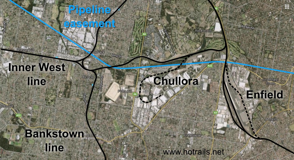
Chullora and Enfield railyards, as well as Sydney Water pipeline easement (blue). Base image: Google Maps
There is an additional possibility of using the Enfield Yards to get us as far as Campsie Junction (10.6km from Central). However this would require substantial ancillary works and possibly additional tunnel to achieve, and would additionally have inferior geometry.
Pipeline easements
While trawling Google Earth for straight and wide transport corridors, I made the interesting discovery of the Pipehead to Potts Hill Pipeline, otherwise known as the “Six Foot Pipelines”. These were built between 1888 and 1925 to supply water from Prospect Reservoir to the Potts Hill Reservoir and water treatment facility. Back then, there was little development this far out of Sydney, so the pipeline easement is particularly wide and straight – possibly sufficient for co-utilisation by rail. It would be possible to interface with the Cumberland Line around Yennora Station. However this would be a somewhat inferior alignment to the Chullora alignment suggested above, and would not necessarily reduce the amount of tunnel required. If there is sufficient capacity within the Inner West Line corridor, then utilising the pipeline corridors is unnecessary.
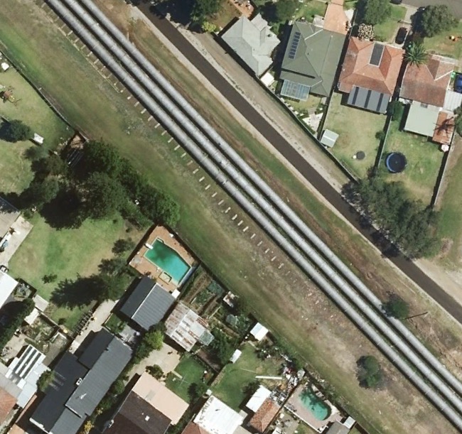
The “Six Foot Pipelines” near Guildford. Corridor is 40m wide.
The Sydney Water pipeline easement actually continues through the Chullora yards on approximately the same position that a fast railway might take, and then extends further into suburban Strathfield underneath Humphries Reserve (actually a pipeline reserve). If this could be utilised as a rail corridor (probably requiring some property acquisition and infrastructure redevelopment) it could potentially bring us as close as 10km from Central.
Comparison to the 2013 government study
Below are the southern Sydney access corridors considered by AECOM’s 2013 high-speed rail study. The preferred option includes a 32km tunnel from Holsworthy all the way into Central. The study does not specifically document its projected cost, except for noting that $6 billion of tunnel would be required between Central and the Southern Highlands station (slated to be located northeast of Mittagong Airport). However if we use their cost estimate of $170m/km for an urban twin-bore tunnel with a 400km/h design speed, we can deduce that this tunnel alone would cost $5.44 billion – that excludes everything else like track, signalling, stations, etc.
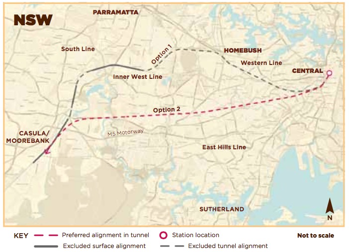
2013 government study options for getting from Glenfield to Central. Lots of tunnel.
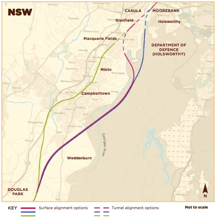
2013 government study options for getting from Douglas Park to Glenfield. The study preferred the blue option; the green option is substantially similar to the route preferred by Hot Rails.
If Hot Rails were to adopt the same alignment, but de-specced to a 200km/h design speed and single bore, the cost would be reduced to $1.98 billion. How much time do we lose for a $3.5 billion saving?
Let’s assume a reasonable acceleration of about 0.5m/s2 (1.8km/h per second – this is similar to what the TGV can achieve up to about about 300km/h). It’s therefore going to take a 350km/h train about 194 seconds to reach full speed, during which time its average speed will be 175km/h and it will travel about 9.4km. The remainder of the tunnel (22.6km) will be traversed at 350km/h, which will take 232 seconds, resulting in a total travel time (Sydney to Glenfield) of 426 seconds (about 7 minutes, 10 seconds).
On the other hand, the 200km/h train will take only 111 seconds to reach full speed, during which time it will travel just 3.1km, with the remainder of the tunnel (28.9km) taking 520 seconds. The total travel time is thus 631 seconds (10 minutes 31 seconds). So our saving of $3.5 billion comes at the cost of an extra 205 seconds (3 minutes 25 seconds) – that’s a saving of $17 million per second!
We will consider this the “baseline option” for comparison with the Hot Rails alternatives. A Hot Rails alignment utilising the corridor options identified above will be explored over the next few posts.