← Moss Vale Previous | Next Yerrinbool →
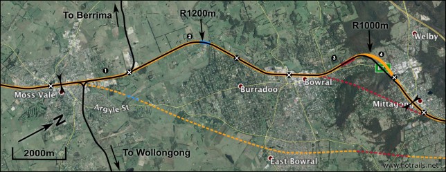
The geography between Moss Vale and Mittagong presents a significant barrier to infrastructure development, both due to the built up areas of Bowral and Mittagong and also the imposing topography of Mt Gibraltar. For this reason, re-use of the existing corridor is the best and probably only option here. Thankfully it is possible, with minor modifications, to maintain the minimum 1000m radius for curves. Other corridor options are limited, and are likely to be prohibitively expensive due to land acquisition costs or tunnelling requirements.
Alignment design
Summary
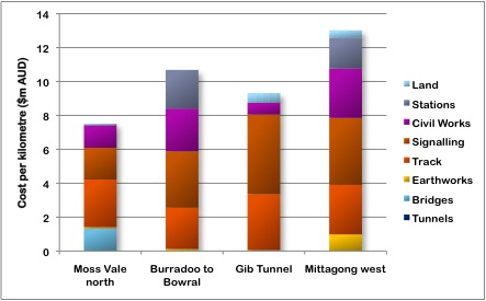
The total cost of the sector between Moss Vale, Bowral and Mittagong is $135.6 million, at an average cost of $9.50 million per kilometre. This is relatively expensive compared to earlier sections, and considering the sector is almost entirely on the existing corridor. You can see in the graph below that the bulk of the cost is actually in track and signalling, due to the complex trackwork and sophisticated signalling infrastructure that is needed at each station. Looking at it another way, the cost of this sector is pretty good on a cost-per-number-of-houses-within-walking-distance-of-an-HSR-station basis.
Faster alternatives
A more direct option at Mt Gibraltar to avoid the 1000m radius curve is a longer tunnel from Mittagong Station to slightly up-track from Bowral Station. Whatever the details, this would be an extremely expensive deviation. The tunnel would have to be a minimum of 2500m long, but probably 4000m or more if we wish to avoid demolishing a large swathe of historic Mittagong. On these numbers the tunnel alone would cost between $155 and $248 million, and is therefore not considered viable.
A second option for a very fast transit is to bypass Bowral and Mittagong entirely, building a new alignment to the south. This would still require a tunnel of about 2km long, as well as the acquisition of perhaps 20 houses in East Bowral at a probable cost of $750,000 each. In addition to still being relatively expensive, this option also has the disadvantage of not accessing either Bowral or Mittagong stations, and therefore fails one of the primary rationales of the Hot Rails strategy.
Moss Vale north
Section length 6880m, sector start. The exit from Moss Vale is fairly unproblematic, with the existing corridor being sufficient for high-speed operation. A third track will be added on the west side of the existing, with one track being upgraded to high-speed and the eastern track retained as a freight line. The Berrima branch line is still in use for freight, so a major grade separation will be required to join cross the high-speed lines. The Wingecarribee Bridge is an old steel girder design, probably of insufficient strength for high-speed operation, and only twin-track at any rate. It will be replaced by a new, triple-track culvert bridge. The bridge is located on a 1200m-radius curve; to increase this to a more desirable 1500m radius is relatively simple but probably will not offer significant advantage, due to the 1000m-radius restriction up-track of the Gib Tunnel which will restrict speeds in this sector anyway. The section ends at Burradoo Station.
Burradoo to Bowral
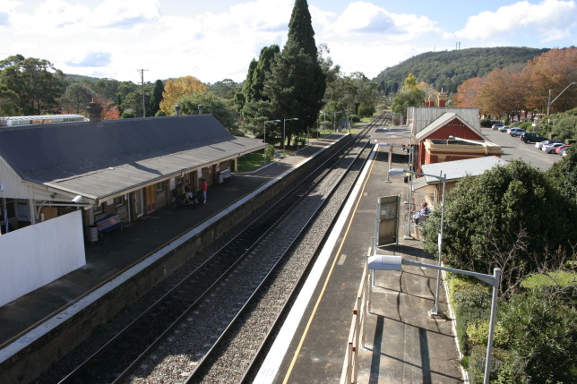
Northbound view at Bowral Station; Mt Gibraltar can be seen in the distance. Image: Grahamec (Wikimedia)
Section length 2500m, starting at 6880m. Very little change to the existing alignment, other than widening it to triple track. There is existing room in the corridor to widen to triple-track, excepting at the platforms of Burradoo and Bowral stations. The road overpass just prior to Bowral Station will require rebuilding to accommodate triple track, and the station also will require a rebuild of the western platform to accommodate the high-speed lines, while the freight line will remain on the east.
Gib Tunnel
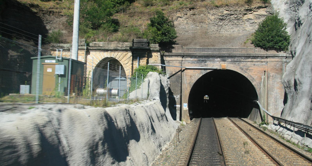
Southbound view of the Gib Tunnel, with the old tunnel visible at left. Image: Woosang (Flickr)
Section length 1750m, starting at 9380m. As noted at the top of this post, Mt Gibraltar presents a formidable barrier to a railway. By far the easiest and cheapest option is to re-use the existing 516m long double-track tunnel. It may also be possible to re-open the original single-track tunnel (built 1867) for use by freight trains. This tunnel is immediately to the east of the newer tunnel, and presumably is of sufficient size to accommodate modern intermodal freight trains. This tunnel is currently home to an exotic mushroom farm, of all things, so it would have to be bought out and relocated, perhaps to another disused tunnel nearby such as the Redbank or Old Main Tunnels at Picton.
Mittagong west
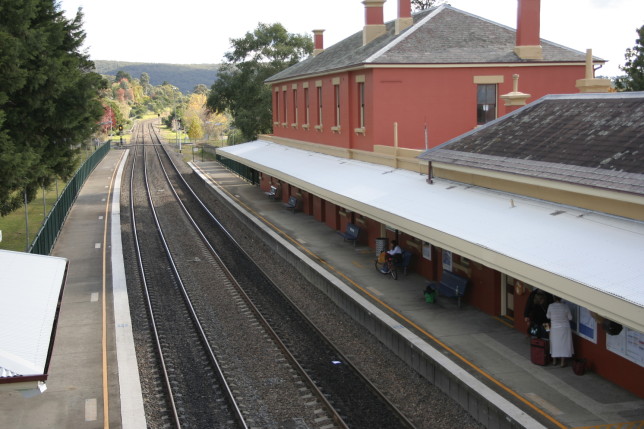
Southbound view from Mittagong Station. Image: Grahamec (Wikimedia)
Section length 3140m, starting at 11130m. Subsequent to the Gib Tunnel, the existing track curves sharply into Mittagong. The existing track will remain as a freight line, with the new high-speed lines being built to the north, partially on the old pre-1919 alignment (which has, strange to say, a more gentle radius than the newer section). A section of noise-attenuation wall will be required due to the proximity of this new alignment to the Gib Gate School (which will additionally require a new main entrance and car park!). A short section of Old Bowral Road will also need to be re-routed. Mittagong Station will require the southern platform rebuilt to accommodate a new freight line on the southern side, however its existing status as a commuter station on the intercity network means the station building itself will require minimal renovation.


