← Yerrinbool Previous | Next Campbelltown →
In this 20-kilometre stretch, the line enters a sustained gentle-to-moderate descent from the Southern Highlands down into the Sydney Basin, dropping over 300m in altitude. There aren’t a lot of plausible corridor options here; the Hume Highway already occupies by far the best one, and it is of sufficient straightness and flatness for a high-speed rail alignment. Thus, either adjacent to or in the middle of the Hume is again where we will look for our railway.
Alignment design
There are only really three options here: Do we go west of the Hume, east of it, or on the median strip? Or perhaps a combination of these options?
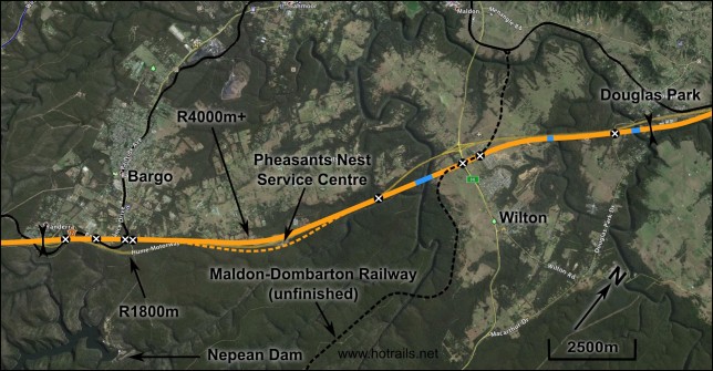
Upper Nepean plan – click to enlarge. Google Maps link
We will discount the option of going largely eastward, due to the closeness of the existing Hume corridor to the Upper Nepean gorge. The median strip option is likely to be the simplest and cheapest, but it is limited in its minimum radius of 1800m, and will only be adopted if also adopted in the previous and subsequent sectors. The western option is fairly desirable save for the deviation at the Wilton Interchange which would require substantial land acquisition.
The ideal option appears to be the western option until after the Pheasant’s Nest service centre, subsequently crossing the Hume where it deviates for the Wilton Interchange, crossing the Nepean to the southeast of the existing highway crossing, and utilising part of the unbuilt Maldon-Dombarton rail corridor before rejoining the Hume corridor on the east until Douglas Park. The elevation profile of this alignment is shown below.
At first glance it looks particularly straightforward – nice, gentle and sustained descent, no prominent earthworks, a few moderately long-spanned bridges. But the vertical scale is deceptively large – each gridline represents fifty vertical metres! The fills and cuts barely visible behind the yellow band of the rail alignment are actually between 5 and 10 metres in peak height/depth. Not particularly challenging from an engineering standpoint, sure. But certainly not insignificant either.
Yanderra exit – 4.1km
Getting out of Yanderra is surprisingly difficult due to existing infrastructure, with our line having to cross the existing freight railway (three times), both highway onramps and Avon Dam Road. The onramps and the first railway crossing are sufficiently close that we’ll call this a major grade separation ($5m). Checking this with the bridge cost functions checks out very closely (180m bridge with 20m spans comes to $5.4m). Four quite new houses on large blocks will have to be acquired. After crossing Avon Dam Road the alignment proceeds through bush to join the western side of the Hume corridor.
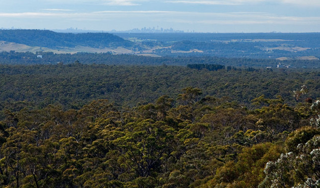
Sydney CBD visible in the distance. Image: NPWS
Pheasants Nest – 6.2km
The curve of the highway at Pheasants Nest has a radius of 3000m, so it would be great to stick closely to the existing corridor here. Unfortunately there is a service centre on both sides of the highway, pretty much right on the apex of the corner. If we were to stick to the Hume verge, two major grade separations would be required at both the on and off ramps, and their complex construction would probably mean they cost more than the $5m each we assume. Instead, if we increase the radius of the rail curve to 4000 or 5000m, we can bypass to the rear (west) of the service centre. This means that approximately 19ha of private property will need to be acquired; the area between the rail and road alignments can be returned to bushland and used as an environmental offset.
Wilton – 5.5km
The Wilton section begins 10.3km into the sector. We need to cross the Hume Highway at quite a shallow angle; the Hume is on the high ground here so it is most sensible for us to go under it. Using the tunnelling cost functions for a 200m tunnel gives us a cost of $12.4m, slightly more expensive than two “major grade separations”. This seems reasonable, especially given the tunnel will be constructed by cut-and-cover rather than tunnel boring machine. Some substantial earthworks is required for the bridge approaches.
The bridge over the Nepean River is the largest we have done so far in Hot Rails, at least spanwise. If we build to the same specifications as the Hume Highway bridges a little to the west, it will have a 150m mainspan. Judging by the terrain, it looks like 350m total length would be reasonable. Due to both the length of the mainspan and the deep-v terrain, a deck-arch bridge is most appropriate for the location. It is estimated to cost $34.1 million.
Subsequent to the first Nepean bridge, the alignment uses a section of the unfinished Maldon-Dombarton railway corridor for about 1.2km. Although there have been a few calls for the line to be finished, there are presently no firm plans for construction to resume. The Hot Rails alignment then passes through the Bingara Gorge residential development. Although mostly using part of the golf course reserve, up to 8 blocks (currently unoccupied, but which probably won’t be by the time the railway is built) would have to be acquired. Due to the closeness of existing development, a noise-attenuation wall will be built in this location.
Douglas Park – 4.4km
Beginning 15.8km into the sector, the alignment rejoins the Hume Highway corridor on the east. Two bridges are required. The first is a 275m bridge consisting of ten 27.5m spans over Allens Creek costing $9.0m, while the second is a 250m bridge consisting of five 50m spans, costing $12.5m. Three minor grade separations are required: the first near Wilton to extend an existing farm crossing over the Hume Highway, the second at Douglas Park Rd and the third at Prices Road. The sector finished adjacent the dog-leg in Prices Road, 300m to the southwest of the Hume.
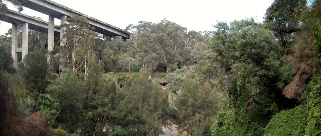
View of the Hume Highway bridges at Douglas Park from the road below. Image: Alan Farlow
Summary
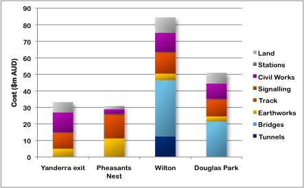
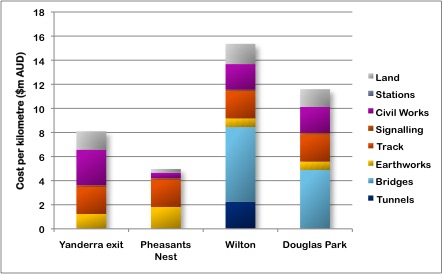
The total cost of the Upper Nepean sector is $199.5m, or $9.88m/km. This is pretty good value, slightly below the Hot Rails average. The minimum radius in this sector is 4000m+, leaving open the possibility of future speed upgrades (350km/h should be possible with a TGV-style train). Cost breakdowns for each section are presented below, in both absolute and per-kilometre terms.
What about the “cheap” median strip option?
If we were using the median strip rather than having to acquire a new corridor, we would avoid most of the civil works and earthworks expenditure, all of the land and tunnel expenditure, but none of the bridge expenditure. The track/drainage/barriers would cost $3.3m/km x 20.5km (slightly longer due to being curvier) = $67.7m. Bridges might actually cost more due to having to build them in such close proximity to the existing infrastructure, but assuming they cost the same amount it would bring the total to $123.3m. Add in a bit more for civil works (say half the cost – building stuff in the middle of a highway requires substantial traffic control) and we’ll come to $141.4m. This is a substantial saving of about $58 million – a quarter of the cost of this sector, and about 5% of the total expenditure to date on the entire Southern Highlands line. However we will still reserve judgement until we’ve analysed the final sector into Campbelltown – my gut feeling is that it would be a shame to abandon the possibility of future speed upgrades for such modest extra expenditure.


I reckon there should be a station at Wilton to serve the growing town centre. There can be regional services between Sydney and Southern Highlands calling at Wilton in a similar manner to how some Regional Trains between Munich and Nuremberg call at smaller stations along the Nuremberg-Ingolstadt line (Allersberg and Kinding). These can act as cheaper alternatives to High-Speed rail albeit operating at slower speeds but still significantly reducing travel time between Sydney and Southern Highlands from the current travel times (even with direct services)