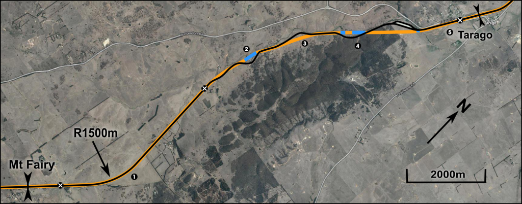
This sector follows the existing alignment through the Mulwaree River valley. While the first half is straight and uses the existing alignment exclusively, subsequently two minor deviations (albeit requiring four bridges) are required to straighten some very tight curves. Major earthworks are confined to the final few kilometres before Tarago.
Alignment design
Summary
The total cost of the sector is $97.3 million, averaging $7.3m/km. For a sector with significant bridges, this is excellent value – again, it is due to the substantial length of re-used alignment. The minimum radius in this sector has been increased from 240m to 1500m, increasing the maximum speed from about 60km/h to well over 200km/h for most types of train. Gradients have been kept below 2% throughout, ensuring the trains can achieve maximum speed efficiently.
There are few plausible options for establishing a route with 3000m radius curves for future upgrade to very high speed. The Mulwaree River curves could probably be lengthened further if less existing alignment were re-utilised, at the cost of extra earthwork. Likewise the initial curve after Mt Fairy could be eased by cutting into the hillside. An entirely different option would be to continue straight after Mt Fairy, with a deep cutting through the saddle of the ridge, before running roughly alongside Braidwood Road. However this option would preclude the use of Tarago Station, which makes it an inferior choice on its own. The option presented here is sufficient for 250km/h operation of tilt-trains, and therefore amply satisfies the requirements of Hot Rails.
[table]
Component,Cost ($m),Percentage
Tunnels,0.0,0.0%
Bridges,35.0,36.0%
Earthworks,10.6,10.9%
Track,28.9,29.7%
S&C,9.7,10.0%
Civil works,11.9,12.2%
Stations,1.0,1.0%
Land,0.2,0.2%
TOTAL,97.3,100%
[/table]
Mt Fairy exit
Section length 5600m, sector start. The first section follows the existing alignment. The one curve encountered is 1500m in radius, which is sufficient. Earthworks required are minimal: balanced cut-and-fill along the whole length, with an average depth of perhaps 2m. One farm crossing and one minor grade separation (for Mt Fairy Road) are required.
- Earthworks
- 5.6km balanced cut-fill widening, depth 2m
- 67200m3, $1,008,000
- 5.6km balanced cut-fill widening, depth 2m
- Track
- Upgrade 1, add 1: $10,500,000
- Signalling & Control: $711,000
- Civil Works
- Chainlink fence, both sides: $220,000
- Drainage: $440,000
- Grade separations
- Farm underpass: $500k
- Minor grade separation: $1.25m
First Mulwaree crossing
Section length 1660m, starting at 5600m. Although completely new alignment, it stays mostly very close to the existing alignment. The approach to the bridge involves a long balanced cut-and-fill to straighten some curves: a 250-m fill will require a retaining wall of perhaps 2m in height to prevent impinging on the river, and a 280m cut immediately after will provide the rubble. The bridge itself actually crosses the river twice, touching down on the far bank in the centre of its length. The bridge would have to be 420m in total length, with a mainspan of 30-40m required. 14 equal spans of 30m would be a simple design and maintain similarity with other bridges in the system.
- Bridge cost function 11725e0.012*30
- $16,806/track-m
- Total=$14,117,000
- Earthworks
- 1.24km balanced cut-fill
- 34720m3, $556,000
- Track: $3,735,000
- S&C: $211,000
- Civil works
- Chainlink fence, 1.24km both sides: $124,000
- Drainage, 1.24km: $248,000
- 250m retaining wall, 2m high: $1,250,000
- Land: assume 40m easement required whole length.
- 6.64ha @ $10k/ha = $66,400
Mulwaree deviation
Section length 2200m, starting at 7260. This section is partially on existing alignment, with a short deviation through a low hill to straighten a curve. Minimum radius in this section is increased from 240m to 1500, although larger would be possible with a longer deviation and more substantial earthworks.
- Earthworks
- 680m cut, 4m deep: 43520m3, $1,349,000
- 1520m balanced widening:
- 9120m3, $146,000
- Track
- 680m new dual: $1,530,000
- 1520m upgraded & duplicated: $2,850,000
- S&C: $279,000
- Civil works
- Chainlink fence: $220,000
- Drainage: $440,000
- Land: 680m new corridor (40m)
- 2.7ha @ $10,000/ha = $27,000
Second, third and fourth Mulwaree crossings
Section length 2300m, starting at 9460m. Crosses the Mulwaree river three times and requires two fairly significant cuts and a large fill.
- 2nd crossing: 3 spans of 40m
- Cost function 11725e0.012*40
- $18,949/track-m, 1.15x multiplier for triple span
- = $5,230,000
- 3rd crossing: 9 spans of 40m
- $18,949/track-m, = $13,643,000
- 4th crossing: 3 spans of 20m
- Cost function 11725e0.012*20
- $14,905/track-m, 1.15x multiplier for triple span
- = $2,057,000
- Earthworks
- First cut: 270m @ 10m deep
- 59400m3, $1,841,000
- Second cut: 740m @8m deep
- 118400m3, $3,670,000
- Fill: 480m @10m high
- 129600m3, $2,074,000
- First cut: 270m @ 10m deep
- Track: $5,175,000
- S&C: $292,000
- Civil works (non-bridge length = 1760m)
- Chainlink fence: $176,000
- Drainage: $352,000
- Land: assume 40m corridor required whole way
- 9.2ha @ $10k/ha = $92,000
Tarago approach
Section length 1580m, starting at 11760m. Rejoins the existing alignment at the start; a single, low-speed turnout will be required to maintain access to the Woodlawn Intermodal Transfer Station. Subsequently it is an easy run on a flat, straight alignment into the centre of Tarago. A major grade separation will be required on Tarago Road, as well as a crossover and associated signalling. Tarago station has an attractive, Federation-styled main building which is in good condition, but the entire station will require substantial renovation for integration into a major rail network.
- Track
- Upgrade and duplicate: $2,963,000
- 3x low-speed turnouts: $2,100,000
- S&C
- Cable and balises: $201,000
- 2x turnout signals (one for freight yard, one for station approach): $8,000,000
- Civil works
- Security fencing (both sides): $316,000
- Drainage: $316,000
- Major grade separation: $5m
- Station upgrade: $1,000,000


