


West | East Towrang →
The first sector of the Southern Highlands Line encounters a new problem – that of sharing the corridor with existing traffic, most particularly slow freight trains. The corridor is already near capacity, therefore it is likely that sharing tracks would result in the faster trains becoming stuck behind slower trains. For this reason, any sections of shared track should be upgraded to triple track.
Additionally, the freight line will most likely have to remain on its existing alignment (due to a lower tolerance for steep grades). Therefore where consecutive deviations from the existing corridor occur, they must enter and leave the corridor on the same side, ie, no at-grade crossings of the freight line can occur.
This does however have the advantage that lower performance upgrades on the existing line will still be useful to the remaining freight traffic even if a very fast alignment is built in the future. Thus we don’t need to be so mindful about avoiding obsolescence. That said, it would be rather silly to end up with a triple-track freight line, so alignments that are liable to be superseded will be merely upgraded to high-speed dual track and not increased to triple-track.
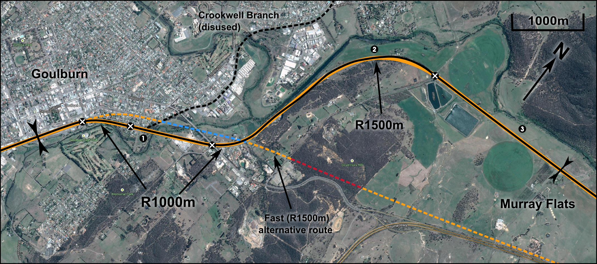
The existing alignment out of Goulburn has a minimum radius of 600m, yet it should be possible to increase to 1000m or possibly 1500m with only small modifications to the existing corridor. Geography, other transport corridors and existing development impose substantial constraints beyond this; any faster deviation will be very expensive and should therefore be deferred until higher-speed operations are required.
Alignment design
The existing rail corridor is suitable with only minimal changes to the alignment. Existing curves are of 800m radius, which can be increased to the required 1000m with minor alignment changes, and in some cases some minor demolition or earthworks. The slight bends along the section adjacent the Mulwaree river will be straightened, and the double-apex curve near the Goulburn Gaol will be realigned to a single, R1500m curve.
Proposed alignment – click to enlarge
1 – Station exit
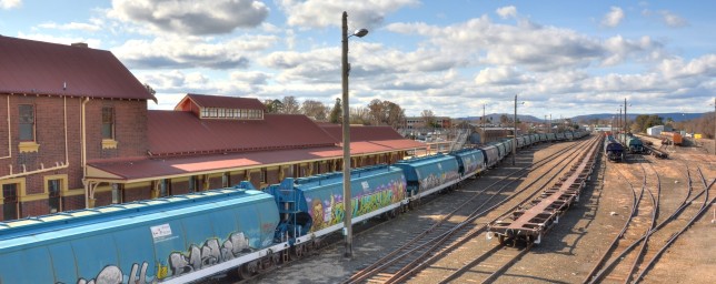
Looking Sydney-bound (north-east) from Goulburn Station. Image: Hot Rails
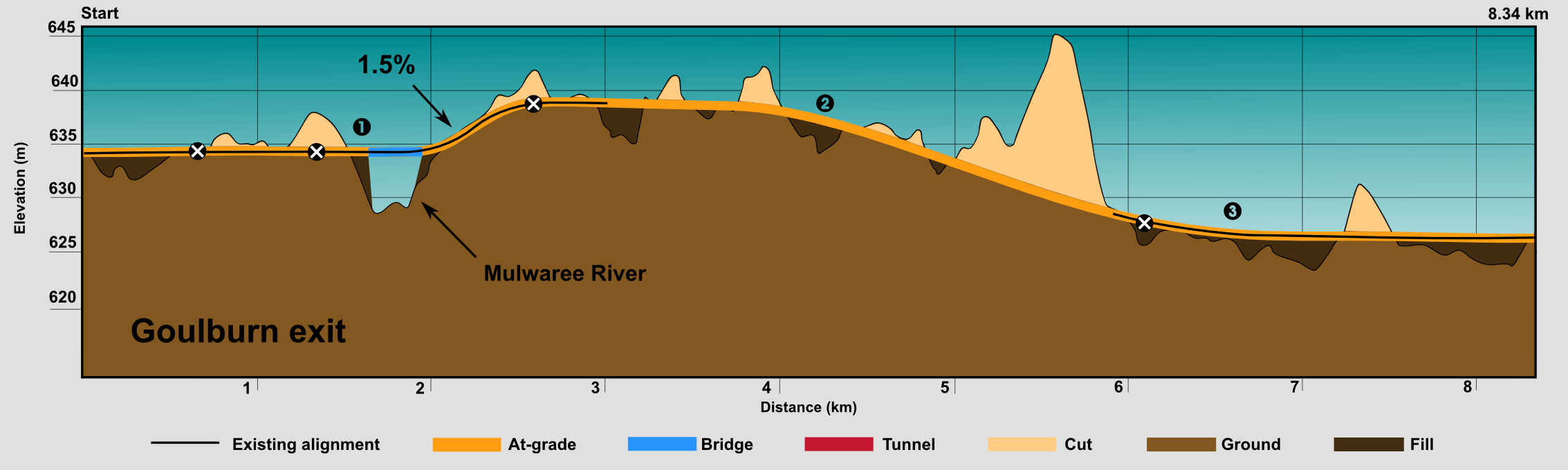
Section length 2330m, sector start. This sector will be upgraded to triple-rail. The twin-passenger tracks begin together at the split-platform station with the single freight line running parallel to the east. A new road overpass will be required at Blackshaw Road. From the station exit to the end of the first curve, the rails will need to be removed and completely realigned in order to increase the radius from 800m to 1000m; it may be possible to achieve this without the demolition of any structures, as the existing corridor already allows for triple track.
After the curve, a third track is added on the north side (reinstating a track which was removed in the past). The Phillip St overpass already caters for quadruple track and will not need upgrading. There are existing bridge pylons on the north side of the Mulwaree river and floodplains crossing which can be re-used for a new single-track bridge. There are 11 pylons and 12 spans of 20m each, for a total bridge length of 240m. Although the stone pylons from the previous single-track railway remain, the bridge will be assumed to cost the same as an all-new bridge. The existing dual-track bridge will be retained. The sector ends adjacent Heatherington St, prior to the Sydney St underpass.
- Bridges: 12 spans of 20m each, existing pylons
- Total cost $3,577,000
- Earthworks: none, existing corridor is used throughout.
- Track
- 1200m of newly aligned triple-track: $3.906m
- 1130m of upgraded dual track with one new track: $2.831m
- 3 low-speed turnouts: $2.1m
- Signalling and Control
- Cable and balises: $296,000
- 3 crossover signals: $12m
- Civil works
- Site clearance and demolition in station precinct: $125k
- Steel palisade fencing along entire length excluding bridge: $418k
- Drainage: $466k
- Utilities relocation in station precinct: $575k
- Minor grade separation at Blackshaw Rd: $1.25m
- Land: All within existing rail corridor
Section cost: $27.54m ($11.8m/km)
2 – Curve reshaping
Looking east from the Sydney Road overpass. Image: Google Maps
Section length 3930m, beginning at 2330m. This sector consists of two curves following the Mulwaree River valley; they must be reshaped to increase radius to 1000m.The Sydney Road overbridge must be widened to accommodate triple track, as must a minor overpass next to it. This will probably require the complete replacement of the structures (see the image above). The new alignment will be built on the existing wide rail reserve north of Long St, where there is an existing borrow-pit; this will minimise the amount of earthworks required. The alignment will most likely require minor changes along the entire length; for this reason it will be assumed that all-new track is required (although in reality much of the existing rails and sleepers will be re-used, and only two tracks will need to be HSR quality). The second curve will require a land corridor of approximately 50m in width to be acquired over half of its length (the other half can be accommodated in the existing wide rail reserve). The second half of the curve will be in a cutting of approximately 8m depth. Gorman Road will need to be grade-separated.
- Earthworks
- 2000m of balanced cut/fil, 2m avg depth
- $1.26m
- 700m rock cut, average 8m depth
- $4.513m
- 2000m of balanced cut/fil, 2m avg depth
- Track
- New triple track along entire length: $12,792,000
- Signalling and Control
- $499,000
- Civil works
- Site clearance, removal of old rails: $491,000
- Chainlink fence: $393,000
- Drainage: $786,000
- Major grade separation @ Sydney Road: $5m
- 2 Minor grade separations: $1.25m each
- Land: Assume 1km long corridor, 50m avg width, $20k/ha for township-fringe rural land
- $97,000
Section cost: $28.33m ($7.21m/km)
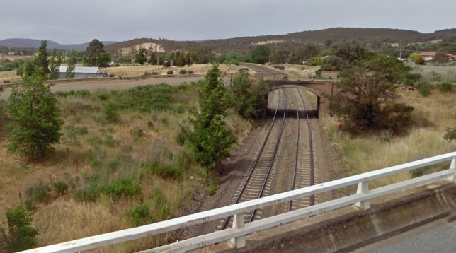
3 – Murray Flats
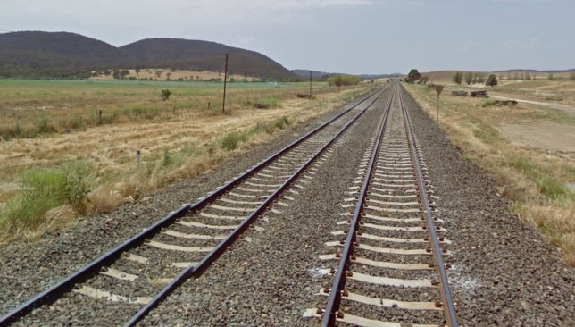
Looking east towards Murray Flats at the Gorman Rd level crossing. Image: Google Maps
Section length 2080m, beginning at 6260m. This section is very simple – just a matter of upgrading the northern track to HSR and reinstating the third track on the north side (the southern track will remain a freight-only track and thus requires no upgrade). There is no earthwork required as the new track will be built on an existing alignment. There aren’t even any farm underpasses required.
- Track: Upgrade one track, one new track
- $3.9m
- S&C: $264,000
- Civil works
- Chainlink fence: $208,000
- Drainage: $416,000
Section cost: $4.79m ($2.30m/km)
Summary
The total sector cost is $60.62m, at an average of $7.27m/km. Although relatively expensive for a sector in which we have stayed entirely within the existing corridor, this good value considering this is a triple-track sector, and still within a semi-urban area for approximately half its length. Minimum radius is 1000m for the inner-township curve, which will allow transit speed of 200km/h (or 180km/h for a less aggressively canted track that can be shared with freight trains). The second curve will achieve between 1200-1500m radius, which will allow up to 250km/h (225km/h if shared with freight).
A faster alternative alignment was considered that uses an entirely new corridor that eventually joins the Hume Highway corridor. It takes a gentler (R1500m) curve on exit from the station precinct, requiring the demolition of approximately 12-20 homes, and the closure of the eastern end of Grafton St. Then an 800m long viaduct/bridge and 1000m long tunnel is required to exit Goulburn. The substantial capital cost associated with this option, as well as the fact that speed gains would probably be mild due to the urban location of the corridor, count against its selection.
[table]
Component,Cost ($m),Percentage
Tunnels,0.0,0.0%
Bridges,3.6,5.9%
Earthworks,5.8,9.5%
Track,25.5,42.1%
S&C,13.1,21.5%
Civil works,12.6,20.8%
Stations,0.0,0.0%
Land,0.1,0.2%
TOTAL,60.6,100.0%
[/table]
Fascinating work – how current are these coatings?
Hi Ursula, the costings are just rough order-of-magnitude estimates taken from a range of sources, but mostly based on the 2013 HSR study commissioned by the Rudd/Gillard government. You can see a detailed explanation of all cost assumptions here: https://hotrails.net/resources/cost-estimates/